
There are two broad classifications of airspace: controlled and uncontrolled. Class A, B, C, D, and E are categorized as controlled airspace. Class G is uncontrolled airspace. Class G airspace extends from the surface to the base of the overlying Class E airspace. New recreational UAS operating requirements state that to operate in controlled airspace, an operator must obtain authorization prior to flying. An airspace authorization can be obtained through LAANC, DroneZone, or a written agreement with the FAA for those flying from fixed flying sites.
The map below helps operators identify the airspace around them. A red or green circle (often with grids) represents controlled or restricted airspace. Areas without circles represent uncontrolled airspace. We encourage you to take a look at the aforementioned UAS Facility Map to determine the airspace that your operations are taking place.
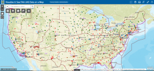
For example, AMA Expo West was held in Pomona, CA which is located in controlled airspace. You can tell this by seeing the location inside a shaded grid.

For example, AMA HQ is in uncontrolled airspace.

Please reference the map legend: Please reference the layers feature:


Please feel free to contact AMA with any questions or for assistance determining the class of airspace at your location.
Kind regards,
AMA Government Affairs Team